

3,600 year old Nebra Sky Disc.
From time immemorial humans have looked to the heavens for the sustenance given by sun and rain, for the celestial bodies that calibrated sowing and reaping, for the gods that needed adulation or appeasement, and for signs that there is a greater power that makes existence more than a throw of the dice. What is it that humans seek in mapping the ground under their feet, the seas that swell up before them and the heavens that arch high above?
In Part 1 of Maps: Defining and Explaining our Past, Present and Future, we explored the ancient history of maps and reasoned that the chronicling of time and place, rendered in a logical web of lines and curves, gives us a sense of belonging, a purpose and understanding, of the world around us. It helps us mediate the raging beauty of nature and, in our minds at least, cast dominion over the earth and stars.
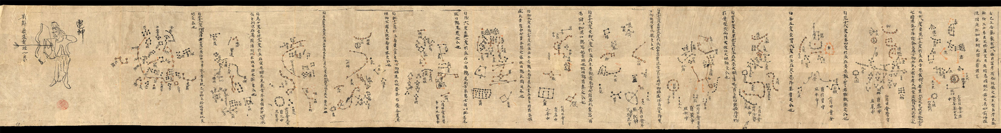
The Dunhuang Star Chart, circa 700 CE.
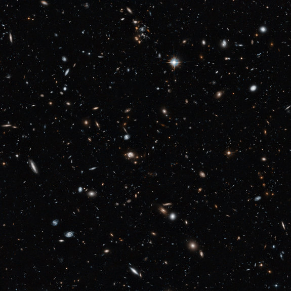
A deep view of the universe courtesy of the Hubble Telescope.
The millennia have revealed a great deal of the earth’s particulars. But humans continue to be lured by the infinite mysteries of the cosmos. From antiquity on, great thinkers and explorers have pondered what lies beyond the heavens we see. While religion, politics, superstition and hubris have sought to define the earth and heavens according to human understanding, the universe has just waited in silent repose. Until now.
Let’s see what the ancients made of the universe and compare how today we are finding innovative ways of capturing the vistas that beckon beyond the stretches of our imaginations. Granted, humankind may seem to be only a speck across the spectrum of time and space. But what a speck we are.
Maps That Explain How the Ancients Viewed Our Universe and How We View it Today
Ancient Astronomy
- An Exhibition of the History of Astronomical Maps– This beautiful collection is provided online by the University of Michigan.
- Ancient Maps of the Universe– From the Library of Congress comes an incredible compilation of ancient depictions of the universe.
- Ancient Representation of the Egyptian Sky– Found on the ceiling of the tomb of Senenmut, this celestial map dates back to the 15th century CE.
- Astronomy of Ancient Cultures– On this site one can learn how numerous ancient civilizations viewed our universe and see the maps and illustrations that ancient astronomers made in their studies.
- Dunhuang Star Atlas– One of the oldest known map of the stars. Found in a cave in China, it is believed to date back to around 700 CE.
- Nebra Sky Disc– According to UNESCO, the 3,600 year old bronze disc is “the oldest concrete depiction of cosmic phenomena worldwide.”
Modern Astronomy
- Images and Maps of the Planets in our Solar System– Google Maps and the SETI Institute hold an incredible collection that allows us to explore our own celestial neighborhood.
- Cartography of the Universe: Mapping What You Cannot See, Cannot Know, Cannot Visit– An article on the NPR blog offers a stunning video map of our supercluster, Laniakea.
- An Atlas of the Universe– A set of nine maps showing our visible universe. Each map is ten times the scale of the previous one.
- Hubble Telescope Fly-Through of a Cross Section of the Universe– This image from the Hubble Telescope provides an unprecedented deep view of the universe.
- Fly-Through of the Largest Map of the Universe as of 2012– The data come from the Sloan Digital Sky Survey III (SDSS-III), and they include measurements from the ongoing SDSS-III Baryon Oscillation Spectroscopic Survey (BOSS), which calculates the distances to galaxies as far as 6 billion light-years away and enormous black holes that lie up to 12 billion light-years from Earth.
- Map-A-Planet– “MAP2 allows users to select global image mosaics, which can then be map projected, clipped to extents, have algebra functions against the image bands, and then converted to the user’s desired file format.”
- NASA Photo Journal– A vast collection of images and maps of celestial bodies that can be displayed with a click on a selected planet.
- Space for Kids!– A fantastic collection from kidsites.com that includes maps and interactive activities to help kids learn about the universe.
Don’t miss Maps, Part 3: Defining and Explaining our Past, Present and Future as we explore the future of cartography.


Pingback: Summer Reading Recap: Asia | AntiquityNOW
Pingback: Summer Reading Recap: Mesopotamia and the Middle East | AntiquityNOW